
At least 22 people have died and 103 people were reported missing in the flash flood in Sikkim after a glacial lake situated in the state’s northwest at 17,000 ft burst due to incessant rains leading to excess release of water downstream.
The army and NDRF teams are working their way through slushy earth and fast-flowing water in the Teesta river basin and downstream north Bengal for the third day in search of those still missing. Of the 23 army personnel who were missing from Burdang area, the bodies of seven have been recovered from different areas downstream while the search is on for 15 missing jawans, Chief Minister PS Tamang said.
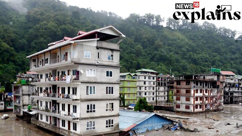
The flash flood in the Teesta River destroyed power infrastructure, and flooded towns and villages, and six people were reported dead in Gangtok, and four each in Mangan and Pakyong.
According to reports, several studies over the years have highlighted South Lhonak Lake’s rapidly growing size due to melting glaciers and marked it as susceptible to glacial lake outburst flood (GLOF).
What is Glacial Lake Outburst Flood?
A Glacial Lake Outburst Flood or GLOF is a sudden release of water from a lake fed by glacier melt, that may be formed at the side, in front, within, beneath, or on the surface of a glacier.
Though glacial lakes are common in the Himalayas, like the South Lhonak Lake, the threat emerges as they grow bigger since they are dammed by unstable ice or sediment composed of loose rock and debris.
When the boundary around the lakes couldn’t withstand the excess water, they break resulting in huge amounts of water rushing down the side of the mountains causing flooding in the downstream areas or the glacial lake outburst floods.
The glacial lakes remain a persistent threat to downstream communities and infrastructure and are generally triggered by several reasons like earthquakes, extremely heavy rains and ice avalanches.
Once the outbursts happen, the immense volume of water flows down rapidly through valleys, gaining destructive force as it descends. The floodwaters carry with them rocks, debris, and sediment, creating a destructive force capable of obliterating infrastructure, villages, and agricultural land downstream.
In case of Lhonak Lake, the flash flood in the Teesta River turned towards Chungthang Dam destroying the power infrastructure, and flooding towns and villages. The flood destroyed 13 bridges in the state, with eight bridges getting washed away in Mangan district alone. Three bridges were destroyed in Gangtok and two in Namchi.
What Happened in Case of South Lhonak Lake?
With rising temperatures across the globe, melting glaciers in the Himalayas are a common phenomenon, which has also been witnessed in Sikkim. The melting glaciers have given rise to many glacier lakes and expanded the already existing ones in the region.
There are more than 300 glacial lakes in Sikkim Himalayan, out of which, 10 including the South Lhonak Lake have been identified as vulnerable to outburst floods, according to a report in The Indian Express.
The lake, at an altitude of 5,200 meters, became the largest and fastest-growing glacial lake in the state, with a glacial retreat of two kilometres in around 5 decades since 1962, a report in Down to Earth said.
In 2021, scientists in a detailed study titled ‘Future Glacial Lake Outburst Flood (GLOF) hazard of the South Lhonak Lake, Sikkim Himalaya’ warned that the South Lhonak lake in Sikkim would burst.
“The width of the terminal moraine that dams the South Lhonak Lake is not uniform and is thinning towards the ends. Hummocky surface of the dam indicates that it likely contains buried ice and be subject to future degradation,” the study reportedly stated.
According to a report, Lhonak has grown nearly 1.5 times and South Lhonak nearly 2.5 times of their initial size since 1989.
The report warned that the earthquake of magnitude 4.9 on Sept 21, 1991 near the parent glacier feeding the South Lhonak Lake and the recent earthquake in September 2011 near the lake may trigger the GLOF events.


Comments
0 comment