views
Google Maps is getting a new feature which will make it easy for users to navigate indoors. Google on Tuesday announced that Maps users will be able to use its Live View feature in certain indoor locations like Airports, transit stations, and malls. The new feature will navigate users indoors using Augmented Reality (AR), where arrows and directions will appear on the the screen, as the user scans the venue with their smartphone. “If you’re catching a plane or train, Live View can help you find the nearest elevator and escalators, your gate, platform, baggage claim, check-in counters, ticket office, restrooms, ATMs and more. Arrows and accompanying directions will point you the right way. And if you need to pick something up from the mall, use Live View to see what floor a store is on and how to get there so you can get in and out in a snap,” Google said in a blog post. Before this, Live View was used for navigating outdoors.
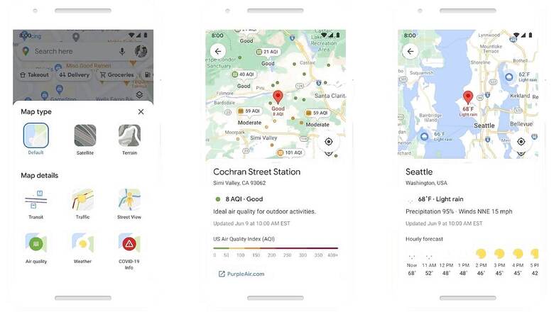
The indoor Live View feature in Google Maps is available on both Android and iOS platforms and can currently be used only in malls in the US including Chicago, Long Island, Los Angeles, Newark, San Francisco, San Jose, and Seattle. The feature will roll out in the coming months to select airports, malls, and transit stations in Tokyo, Zurich, with more cities to be added later on. Apart from indoor live view, Google Maps is also getting several other features like a new weather layer which will allow users to quickly check the current temperature and forecasted conditions. There is also an air quality layer that will show users how clean or unclean the air is. Good feature for those living in Delhi. Apart from these, Google Maps is also getting a feature which will show more eco-friendly routes. “With insights from the US Department of Energy’s National Renewable Energy Lab, we’re building a new routing model that optimizes for lower fuel consumption based on factors like road incline and traffic congestion,” Google said in the blog post.
With this feature, when navigating, Google Maps will default to the route with the lowest carbon footprint when it has roughly the same ETA as the fastest route. Google says that users can still default to the fastest route, but now they will get information to compare the relative CO2 impact between routes. Maps will also alert users if and when they are entering a low-emission zone. The low-emission zone alerts will launch in June in Germany, the Netherlands, France, Spain, and UK, with more countries coming soon.
Maps is also bringing shopping information to Business Profiles and Search, including delivery providers, pickup, and delivery windows, fees, and order minimums. The feature will first roll out on mobile Search with InstaCard and Alberstons stoes in the US. Out of all the new features, the indoor Live View feature is available now on iOS and Android. The other features, including weather and air quality layers, will come to iOS and Android in the coming months.
Read all the Latest News, Breaking News and Coronavirus News here. Follow us on Facebook, Twitter and Telegram.


Comments
0 comment