
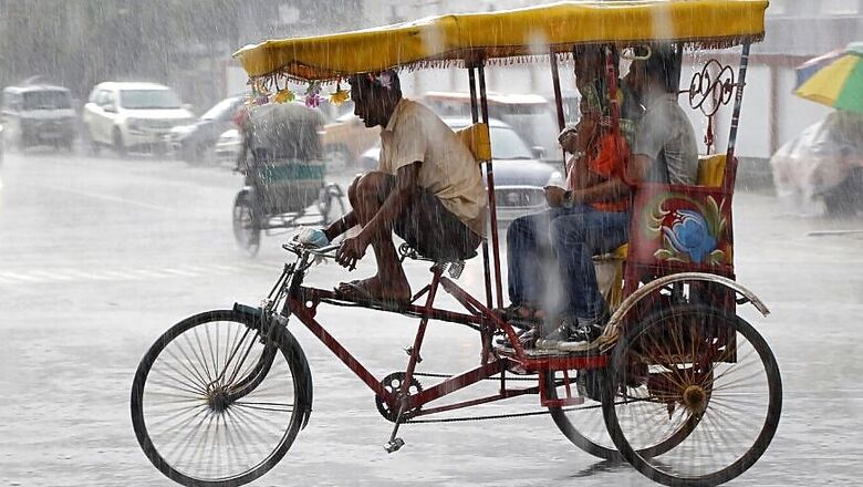
Light-to-moderate rain lashed several states in northern India on Sunday, including Delhi, reducing the possibility of a second heat wave in the region for a week, as the IMD said a low-pressure area over the Arabian Sea could intensify into a cyclonic storm and move into the upper west coast.
The maximum temperature in Delhi was recorded below normal at 36 degrees Celsius due to light showers overnight and through the day, and the weatherman predicted the day temperature is likely to remain below 40 degrees during the next two days.
Several residents of Delhi-NCR witnessed a rainbow in the sky and sports enthusiasts played volleyball after the rainfall. Haryana, Rajasthan and Uttar Pradesh too received rainfall. But Wardha, in Vidarbha region, was recorded the hottest place in India at 43.4 degrees, IMD said.
Kuldeep Srivastava, the head of the India Meteorological Department's regional forecasting centre, said the temperature in Delhi-NCR is likely to increase by 2-4 degrees between June 1 and June 3.
As another western disturbance is expected over northwest India in the first week of June, a heat wave is unlikely to return to the region before June 8, Srivastava said.
A brief spell of heat wave had swept parts of northern India last week.
A fresh western disturbance and southwesterly winds along with the formation of a low-pressure system in the Arabian Sea will bring moisture to Delhi-NCR.
The low-pressure system is likely turn into a depression and then into a cyclonic storm before moving into north Maharashtra and south Gujarat by June 3, said the IMD.
It said the fishermen who have ventured into the sea along the north and south Gujarat coasts should return by Sunday and not go out till June 4.
The Ahmedabad meteorological centre of IMD also advised hoisting of "distant cautionary (DC)-1" storm warning signals at all ports on north and south Gujarat coasts, as the sea condition was very likely to be "rough to very rough," with wind speed reaching 90-100 kmph gusting to 110 mph by June 4.
In southern India, maximum temperatures were appreciably above normal (3.1 to 5.0 degrees) at isolated places in Goa, Tamil Nadu, Puducherry; and above normal (1.6 to 3.0 degrees) in coastal Karnatak, West Madhya Pradesh and Kerala.
Khargone district, 122 kilometres from Indore in Madhya Pradesh, sizzled at 45 degrees Celsius. It was hottest place in India on Saturday at 45.5 degrees Celsius.
The IMD said it will issue the second stage Long Range Forecast for South-West Monsoon Season (June-September) rainfall on Monday afternoon.
Rains lashed parts of Delhi bringing the mercury down and also leading to waterlogging on some stretches of the city roads.
The Safdarjung Observatory, which provides representative figures for the city, recorded a maximum temperature of 34.6 degrees Celsius, six notches below the season's average while the minimum was 20 degrees Celsius.
It gauged 2.2 mm of rain between 8.30 am and 5.30 pm. Humidity levels oscillated between 100 and 55 per cent.
The Palam Observatory recorded 10.2 mm rainfall, Lodhi Road 2.7 mm, Ayanagar 35.1 mm, Delhi University 24.5 mm, Najafgarh 2 mm and Sports Complex 1 mm of rainfall.
The rains, brought in by continued influence of western disturbance affecting northwest India, led to waterlogging in Burari and neighbouring areas of north Delhi.
The weatherman has forecast partly cloudy skies for Monday with the possibility of very light rain. The maximum and minimum temperature is likely to hover around 38 degrees Celsius and 21 degrees Celsius respectively.
With another western disturbance expected in northwest India in the first week of June, a heat wave is not likely to return to Delhi-NCR before June 8, the weather department said.
Kuldeep Srivastava, the head of the India Meteorological Department''s regional forecasting centre, said the effect of the current western disturbance and easterly winds will reduce significantly by Sunday evening.
He said the maximum temperature in Delhi-NCR is likely to increase by two to four degrees Celsius from June 1 to June 3.
"However, the mercury will remain below 40 degrees Celsius over most places and heat wave conditions will not return," he said.
A fresh western disturbance and southwesterly winds along with the formation of a low pressure system in the Arabian Sea will bring moisture to Delhi-NCR, Srivastava said.
These two systems will lead to thunderstorm and light rain over Delhi-NCR between June 3 and June 5.


Comments
0 comment